Exploring LiDAR Technology: The Future of Autonomous Systems
Embedded Systems

LiDAR technology has revolutionized industries like autonomous vehicles, surveying, and environmental monitoring. By offering precise spatial measurements, LiDAR systems provide a critical foundation for mapping and navigation in the modern world.
What Is LiDAR?
LiDAR, short for Light Detection and Ranging, is a remote sensing technology that uses laser pulses to measure distances. By emitting laser beams and analyzing the reflected light, LiDAR creates detailed 3D maps of environments.
The data collected by LiDAR includes distance, intensity, and angle, enabling accurate spatial representation. This makes it an invaluable tool for any application requiring precision in navigation or mapping.
How Does LiDAR Work?
Laser Emission: The LiDAR system emits laser pulses (typically in the infrared spectrum).
Reflection and Reception: The laser pulses reflect off surfaces and return to the LiDAR sensor.
Time-of-Flight Measurement: The time it takes for the laser to return is calculated, providing distance measurements.
3D Mapping: Using multiple beams and rotational scanning, LiDAR systems create high-resolution 3D point clouds of the environment.
Key Applications of LiDAR Technology
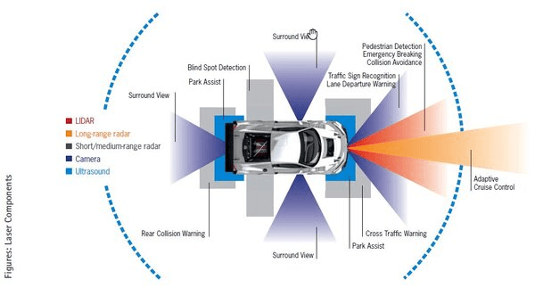
Autonomous Vehicles: LiDAR enables real-time 3D mapping for safe navigation and obstacle avoidance.
Surveying and Mapping: Used in civil engineering, urban planning, and forestry for terrain analysis and site modeling.
Drones and UAVs: Enhances aerial mapping for agriculture, disaster management, and wildlife monitoring.
Archaeology: Helps uncover hidden structures beneath dense vegetation or difficult terrain.
Environmental Monitoring: Tracks changes in coastlines, glaciers, and forest canopies.
Advantages and Limitations of LiDAR
Advantages:
High Accuracy: Provides centimeter-level precision.
Works in Low Light: Operates effectively in both day and night.
Wide Area Coverage: Scans large environments quickly.
3D Capability: Creates highly detailed 3D models for complex analyses.
Limitations:
Cost: High-quality LiDAR systems can be expensive.
Weather Sensitivity: Performance may degrade in heavy rain, fog, or snow.
Power Consumption: Requires significant energy, especially for high-resolution scans.
What to Look for When Selecting a LiDAR Sensor
When choosing a LiDAR sensor, consider the following factors:
Range: Ensure the sensor can detect objects at the required distances for your application.
Field of View (FoV): A wider FoV is critical for autonomous systems or drones.
Resolution: Higher resolution provides more detailed mapping.
Scan Rate: A faster scan rate ensures smoother real-time mapping.
Size and Weight: Essential for drone or vehicle-mounted applications.
Durability: Ensure the sensor is weather-resistant if used outdoors.
References:
"How LiDAR Works," National Ocean Service.
"LiDAR in Autonomous Cars," IEEE Spectrum.
Product specifications from Velodyne LiDAR and Ouster LiDAR manufacturers.


Am I Suitable ?
I would love to collaborate with you! Whether it is launching something new or improving what you already have, I’m here to help transform your vision into a successful reality.
Let’s make it happen!
Have a nice day!
Thanks for visiting my house!
Contact
Ritaniemenkatu, Lahti 15240, Finland
(+358) 46 583 3980